

Introduction of GPS
GPS is a satellite and ground based radio navigation system. It is also called locational system that helps user to determine very accurate locations mostly on the surface of the earth. The radio signals that are broadcasted by satellites are received by anyone who has a GPS device such as SatNav, mobile phone or handheld GPS unit. GPS position is displayed in the form of latitudes and longitudes.
GPS is commonly used in different sectors like aviation, telecommunications, military, surveying, road transportation, farming, Google map, banking, public safety and disaster relief, mobile phone operations, geo-mapping, tracking speed monitoring, auto toll GPS service and so on.
Working principle of GPS
There were about 24 GPS satellites deployed in space on June 26, 1993 about 19300 km above the earths’ surface. They used to orbit the earth once every 12 hours with very high pace of roughly 11,200 km per hour. These satellites are evenly spread out so that four of the satellites are accessible via direct line of sight from anywhere on the globe.
Each GPS satellite broadcasts a message that includes the satellite’s current position, orbit, and exact time. A GPS receiver combines the broadcast signals from multiple satellites to calculate its precise position using a process called triangulation. In this process, at least three satellites are required in order to determine a receiver’s location and a fourth satellite is also used to estimate an accuracy of this location information.
This all process may take time between few seconds to a few minutes depending on the strength and quality of the receiver. In order to increase the speed of the process, most GPS devices also store or cache some information of previous location.
Components of GPS system
There are three segments of GPS system. They are:
a) The space segment: the GPS satellites
b) The control segment: operated by department of defense of US military
c) The user segment: both military and civilian users come under this segment with their GPS equipment.
Image source: researchgate
a) Space segment
- Comprises of 24 satellites circling the earth every 12 hours.
- Present at the altitude of 19300km from earth surface.
- Helps to navigate, store and retransmit the signal message sent by control segment.
- Ensures that the users will have, at least, four simultaneous satellites in view from any point at the Earth surface at any time.
- Among 4 satellites, 3 satellites works for GPS and the fourth satellite works for accuracy.
b) Control segment
- Also known as monitor station.
- Comprises of a master control station and five monitor stations spread around the globe.
- Five monitor stations monitor the GPS satellite signals.
- The information is sent to the master control station if the signals are qualified.
- The signals are revised and sent back to the GPS satellite through ground antennas if there are defects.
c) User segment
- Comprises of GPS that collects and processes signals from GPS satellites.
- Also determines how far away it is from each satellite.
- The accuracy and reliability are enhanced as the number of visible satellites increases.
- The use of this segment is mostly seen in military, civilian applications for GPS in almost every field.
Principle of GPS: Trilateration
The working of GPS is based on the trilateration mathematical principle. Suppose a man is standing somewhere on the earth with three satellites in the sky above him. Consider three circles from A, Band C which intersects exactly at the man’s position. Now the distance between each satellite and the point of intersection is calculated which helps in determining the man’s position on the earth.

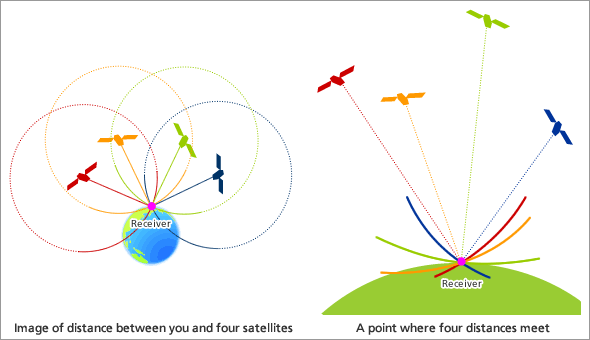
Image source: researchgate Image source: jaxa
Larger the number of satellites above the horizon, location will be more accurate.
In the diagram, four satellites are used to determine the position of the receiver on the earth. Three satellites are used to trace the location place. A fourth satellite is used to confirm the target location of each of those space vehicles.
GPS and Relativity
GPS satellites have atomic clocks on board to keep accurate time. However, general and special relativity predict that the differences will appear between these clocks and an identical clock on the earth. General relativity predicts that time will appear to run slower under stronger gravitational pull. Hence, the clocks on the satellites will seem to run faster than a clock on the earth. Additionally, special relativity predicts that because the satellites’ clocks are moving relative to a clock on earth, they will appear to run slower.
Without considering these relativities, GPS would become almost useless.
Application of GPS
- For air, water and land position detection and navigation.
- For extracting weather information.
- For searching nearby locations like hospitals. ATMs, etc.
- For controlling the guided weapons like missiles.
Shortcoming of GPS
- GPS satellites signals are very weak compared to phone signals.
- The highest accuracy requires line of sight from the receiver to the satellite. Also, it can be significantly incorrect due to limited number of satellites in conditions like indoors, underwater, under dense forests, etc.
References
i) https://www.elprocus.com/how-gps-system-works/
ii) https://gis.depaul.edu/shwang/teaching/geog258/GPS.htm
iii) https://fleet1st.io/blogs/post/what-are-the-3-components-of-gps
iv) https://www.rewiresecurity.co.uk/blog/gps-global-positioning-system-satellites